


LENGTH: 10 km |
LOWEST POINT: 266 m |
HIGHEST POINT: 846m |
TRACK TYPE: asphalt, forest path, macadam, hiking trail |
PARKING: Elementary school Radoboj, at the church, in front of the Nature Center „Zagorje“ |
START/END POINT: Radoboj, Radboa Museum and Nature Center „Zagorje“, (at the roundabout) |
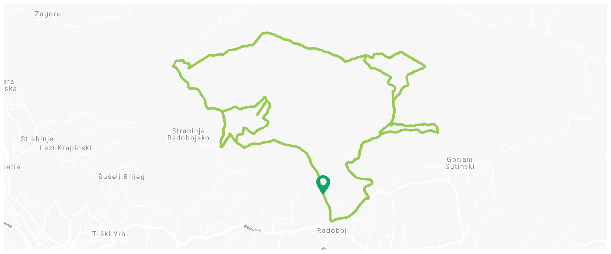
Educational mountain trail: "Paths of the Orchids"
TECHNICAL DESCRIPTION:
Strahinjčica trail (L= 10 km) and „Dedek i Babica“ (grandpa and grandma) trail (L=2.40 km)
1. Starting point at the roundabout, in front of the Nature Center „Zagorje“. We head towards north, down the asphalted road
2. 1.10 km – Y crossing. We turn left to the macadam
3. 2.05 km – arrival to the crossing, starting point of the path leading to the „Dedek i Babica“ trail (2.40 km long path)
– for the “Dedek i Babica” trail we must turn right, going down the macadam. Upon arrival to the crossing near the houses, we turn right and continue down the forest path.
After 1.0 km from the beginning of the “Dedek i Babica” trail, we reach the crossing of a forest path and a trail. There we must take a sharp turn to the left to the hiking trail, where from – by following the ridge – we reach the “Dedek i Babica” peak (562 M.A.S.L.). Then we head back to the previous crossing where we turn left to the forest path. There are around 700 m from the crossing to the main trail towards the Mountain lodge of Strahinjčica.
4. We continue down the macadam
5. 2.60 km – crossing of the paths, before the crucifix. We turn sharply to the right (towards north) and walk down the macadam
6. 3.10 km – crossing of the paths and the trail. Here we must turn left into the woods to the hiking trail and continue down the said trail, following the hiking signs
7. 3.50 km – we reach the forest path, keep walking to the right and down the narrow hiking trail we continue up the hill (by following the hiking signs). After 50-odd meters, we reach the forest path. Following that path, we arrive to the Mountain lodge of Strahinjčica (618 M.A.S.L.; 4.30 km from the starting point)
8. From the Mountain lodge of Strahinjčica we must head towards northeast and turn right at the Y crossing to a narrower forest path. We continue down the said path, following the hiking signs
9. 5.00 km – the rock Dedek (712 M.A.S.L.), arrival to the place with a gorgeous view of Radoboj and Medvednica. From there we continue down the hiking trail
10. 6.00 km – the peak of Sušec (846 M.A.S.L.), the highest point of the trail. From there we continue by following the hiking trails
11. 7.65 km – crossing of Prevaja
– the path leads us to the peak of Sekolje (738,5 M.A.S.L.) at Hajdino zerno, until which we must cross 600 m. From the peak of Sekolje we continue down the hiking trail. If we turn sharply to the right, we follow macadam leading us to the meadow in Poljane where we reach the Orchid trail.
Then we continue following the signs of the Orchid trail that leads us to the end point the Radoboj downtown.
TECHNICAL DESCRIPTION:
Orchid trail (L=4,7 km)
1. Starting point at the roundabout, in front of the Nature Center „Zagorje“. We head towards east down the asphalted road
2. 0.60 km – crossing, we turn left and continue down the main asphalt road
3. 2.00 km – Hunting lodge of the L.D. (hunter’s society) Radoboj (507 M.A.S.L.). We continue to the right behind the Lodge, to the east down the forest path. After 600 m from the Hunting lodge, we reach the meadows in Plat, keeping to the left and then we reach the forest path where we turn left and continue keeping to the left
4. 3.60 km – forest crossing.
– Sharp turn to the right leads us to the meadows in Poljane below Prijevoj and Hajdino zerno.
– Sharp turn to the left leads us to the Hunting lodge of L.D. Radoboj
5. From the Hunting lodge L.D. Radoboj we go back to the starting point by following the same path.